Cap Dramont & Île d’Or: Coastal Walks, Red Rocks and a Little Mediterranean Kingdom
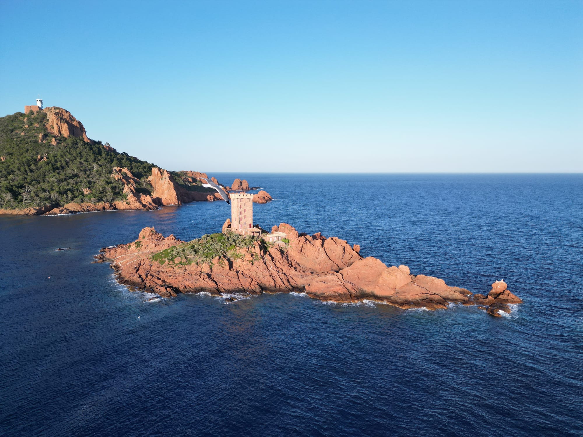
Discover one of the most beautiful corners of the French Riviera, where dramatic red volcanic rocks meet turquoise waters, hidden coves invite you to linger and a tiny island has a fascinating story of its very own king. There are certain places on the French Riviera where the landscape feels almost too perfect to be real. Cap Dramont is one of them. Here, the deep blue of the Mediterranean meets the extraordinary red rocks of the Estérel, with the little Île d’Or standing just offshore like something from a storybook. Add a pretty little harbour, secluded coves, pine trees, coastal paths and one of the most beautiful panoramas along this part of the Côte d’Azur, and you have a place that is very easy to fall in love with. Cap Dramont lies near Saint-Raphaël, along the spectacular Corniche d’Or between Saint-Raphaël and Théoule-sur-Mer. It is an easy and rewarding outing from Gaia’s Villas — and one of our favourite places to recommend when guests want to discover the wilder, more dramatic side of the French Riviera. Whether you come for a beautiful coastal walk, a refreshing swim, a little history or simply the opportunity to take some spectacular photographs, there is plenty to discover here. And unlike some of the Riviera's more famous attractions, Cap Dramont does not require a ticket, a reservation or a particularly elaborate plan. Just bring comfortable shoes, a camera and a little time.
The Red Rocks of the Estérel
The first thing you notice at Cap Dramont is the colour. The Estérel is famous for its intense red and orange rocks, created by ancient volcanic activity. The characteristic rock is called rhyolite, a volcanic rock formed when magma cooled and solidified millions of years ago. Its iron-rich composition gives it those extraordinary reddish hues, which become particularly intense in the warm light of the afternoon sun. The Estérel massif is a geological world quite different from the limestone landscapes found in many other parts of Provence. Its volcanic origins have created a rugged terrain of rocky ridges, steep slopes, dramatic cliffs and little natural coves. At Cap Dramont, you can also encounter a rarer bluish rock known as esterellite, another product of ancient magmatic activity. Both types of rock were historically quarried in the area, and the different colours are particularly interesting when seen together along the coastline. The contrast between the red rocks, the dark green of the umbrella pines and the extraordinary shades of blue and turquoise in the sea is what makes this stretch of the Riviera so distinctive. The vegetation is typically Mediterranean: pine trees, wild rosemary, thyme, shrubs and aromatic plants that release their fragrance in the sunshine. In spring, the hillsides become particularly attractive, with flowering plants adding little splashes of colour to the rocky landscape. It is one of those places where you will probably take far more photographs than you intended. And then you will take another one.
Île d’Or: The Little Island That Looks Like a Fairytale
The undisputed star of Cap Dramont is Île d’Or. The tiny island sits approximately 200 metres offshore, dominated by its distinctive square, crenellated tower built from the same red stone as the surrounding Estérel. It looks almost like a miniature medieval castle floating in the Mediterranean. Depending on the light, the tower can appear deep red, warm orange or almost golden — which is, of course, how the island acquired its rather romantic name. There is, however, a slight catch: you cannot visit the island. Île d’Or is private property and has been privately owned since the end of the 19th century. It is not open to the general public, and visitors should admire it from the mainland or from the water without attempting to land. And perhaps that is part of its charm. You don't go there. You admire it from the coast, watch it change colour as the light moves across the Mediterranean and wonder what it must be like to have a private little island sitting outside your window. It is also remarkably photogenic. From the coastal path, the island appears framed by the red cliffs and Mediterranean vegetation. From Plage du Débarquement, the tower stands almost directly in front of you, while the views from the higher sections of Cap Dramont reveal the island in the context of the wider coastline. It is one of those rare landmarks that looks beautiful from practically every angle.
The Extraordinary Story of Île d’Or
The history of Île d’Or is almost as entertaining as the island itself.Until the late 19th century, it was simply a small rocky islet, one of many along this stretch of Mediterranean coastline. Its extraordinary destiny began in 1897, when it was sold at public auction and purchased by a local architect, Léon Sergent, for just 280 French francs. A few years later, it passed into the hands of Dr Auguste Lutaud, a rather colourful character whose ambitions went considerably further than simply owning a little island. According to local accounts, Lutaud acquired the island following a card game with Sergent, who reportedly used it to settle a gambling debt. The details of this story have become part of the island's folklore, although the subsequent purchase was formalised by a notarial deed in January 1909, for 300 gold francs. Dr Lutaud was clearly not interested in leaving his new property as a bare rocky outcrop. He decided to build something extraordinary: a square tower in a style inspired by Saracen architecture, rather unusual for the region, where round towers influenced by Genoese architecture were more common. Construction began in 1909 and took approximately sixteen months. The stone was extracted directly from the island, while other building materials had to be transported by boat from the mainland. The result was an impressive tower measuring approximately 18 metres in height, with a square base of around eight metres by eight metres. It had several floors, thick stone walls and a crenellated upper section, giving it the unmistakable appearance of a little medieval fortress. The tower was completed in September 1910.
Welcome to the Kingdom of Île d’Or!
And this is where the story becomes particularly delightful.On 19 September 1910, Dr Lutaud organised a grand inauguration ceremony. With guests arriving by boat, music, celebrations and an atmosphere worthy of the Belle Époque, the event was quite the occasion. But Lutaud had one more announcement to make. He proclaimed himself Auguste I, King of Île d’Or. Yes, you read that correctly. He became the self-appointed monarch of his very own Mediterranean kingdom! He adopted royal symbols, created a coat of arms and even had a royal motto: Le salut est dans la sincérité — Salvation lies in sincerity. The inauguration attracted an impressive group of personalities, including the prefect of the Var, Louis Hudelo, the famous medal engraver Oscar Roty and Antoine Lumière, father of the Lumière brothers, pioneers of cinema. Local schoolchildren also took part in the celebrations, and one particularly deserving pupil was chosen to receive a special honour associated with the island. It is easy to imagine the scene: boats arriving from the mainland, elegantly dressed guests stepping ashore, the Mediterranean sparkling in the sunshine and the self-proclaimed king welcoming everyone to his very own little kingdom. If you have built yourself a tower on a private Mediterranean island, apparently the only appropriate thing to do is crown yourself king. Dr Lutaud died in 1925, but his extraordinary little kingdom had already secured its place in local history.
What happened to the island afterwards?
The Second World War brought a much less romantic chapter to Île d’Or. During the German occupation, the tower was looted and damaged, and parts of the island's royal decoration were destroyed. In 1962, the island was sold by Auguste Lutaud's son to François Bureau, a former French naval officer. Bureau undertook an extensive restoration of the tower, which had fallen into a poor state. He repaired the structure, restored its floors, improved its water collection systems and created a Mediterranean garden. Later, a generator and solar panels provided electricity. For him and his family, Île d’Or became a much-loved private retreat. They spent their summers there, maintaining the unusual property and preserving its distinctive character. François Bureau died in 1994 after taking part in the commemorations of the 50th anniversary of the Provence landings. His family placed a memorial plaque on a rock facing the open sea. Further restoration work was undertaken by the family over the following years. Today, Île d’Or remains privately owned and closed to the general public. Its tower, however, continues to watch over the Mediterranean, just as it has done for more than a century.
Was Île d’Or the Inspiration for Tintin?
Here is one of those stories that you will hear repeatedly around the Estérel. Many people believe that Île d’Or inspired Belgian cartoonist Hergé, creator of Tintin, when he drew the island featured in The Black Island (L’Île Noire), the seventh Tintin adventure. The resemblance between the real island and the fictional setting is certainly striking: an isolated rocky island, a mysterious tower and a rather dramatic atmosphere. The island's silhouette, especially when viewed from the mainland, looks almost as though it belongs in a comic-book adventure.Whether Hergé actually used Île d’Or as his direct inspiration remains unconfirmed. It is a popular local theory rather than an established historical fact. But look at the island from Cap Dramont and you can certainly understand why the story has survived. A little red-rock island. A mysterious tower. The Mediterranean all around it. It practically begs to appear in an adventure story.
Hiking Cap Dramont: One of the Most Beautiful Coastal Walks
Cap Dramont is not just somewhere to stop for a photograph. In fact, one of the best ways to appreciate the area is to explore it on foot. The Cap Dramont circular walking trail is a wonderful little excursion, combining beautiful coastal scenery, red volcanic rocks, panoramic viewpoints and a visit to the picturesque Port du Poussaï. The official route starts at Plage du Camp Long and follows the contours of the headland along a combination of coastal paths, rocky tracks and paved sections. The circular walk is approximately 3.8 kilometres long, with around 151 metres of positive elevation gain, and takes roughly two hours at a leisurely pace. It is classified as an easy walk, although some sections are rocky, uneven and occasionally steep. Comfortable walking shoes with good grip are recommended. Flip-flops are best saved for the beach.
Starting at Plage du Camp Long
The starting point is Plage du Camp Long, also known as Tiki Plage, a beautiful sandy beach sheltered between the red rocks and Mediterranean vegetation. From here, follow the small path marked with yellow waymarks along the seafront. The trail follows the natural contours of the rocky coastline, passing through Mediterranean vegetation and opening up to wonderful views of the sea. Almost immediately, the landscape becomes spectacular. The path reaches a rocky overhang before continuing upwards along a narrower section. Take your time here, especially if the ground is uneven or damp. As you climb, the views towards Île d’Or become increasingly beautiful. The island appears and disappears between the rocks and trees, and every new viewpoint offers a slightly different perspective. This is one of the most enjoyable aspects of the walk: the scenery is constantly changing.
Along the cliff tops
At the higher section of the trail, follow the path towards the cliff tops. This is where some of the most impressive panoramas can be found. The red rocks drop towards the Mediterranean, while the views open out across the Bay of Agay and towards the wider Estérel massif. On a clear day, the colours are extraordinary: the deep blue of the sea, the reddish cliffs, the green pines and the lighter turquoise water close to the shore. There are several lovely places to stop and take photographs, although care is needed near exposed edges. Keep to the marked path and avoid venturing onto unstable rocks. At the next junction, the route turns towards the summit, climbing until it joins a paved track leading to the semaphore.
The Semaphore at the Summit
At the summit of Cap Dramont stands the historic sémaphore, a maritime observation station. The headland has been used for observation for centuries. A watchtower was established here in 1562 to monitor the coastline and provide a lookout against potential threats from the sea. The present semaphore developed during the 19th century. Local tourism information traditionally dates its construction to 1860, while the regional heritage inventory documents an earlier 1806 building history and its subsequent reopening and restoration. Its strategic position made it an important point for observing maritime traffic along this part of the Mediterranean. Today, the semaphore remains in active use for maritime surveillance and safety, including monitoring the coastline and pollution risks. It is not open to the public, so visitors should admire it from outside and respect the restricted areas. The surrounding viewpoints, however, are well worth the climb. From here, the panorama stretches across the Bay of Agay, the Mediterranean and the extraordinary red mountains of the Estérel. This is one of those places where you will probably find yourself stopping for longer than expected.
A Detour to Port du Poussaï
On the way back, the official route follows a paved track overlooking the southern slopes of Cap Dramont. Before returning to the starting point, make sure you take the recommended detour to Port du Poussaï. This tiny harbour is one of the most charming corners of the area. Tucked beneath the red rocks, it has a wonderfully intimate atmosphere, with small boats, sheltered water and the surrounding Mediterranean vegetation. Unlike the larger marinas of the Riviera, Port du Poussaï feels much more relaxed and traditional. It is a lovely place to pause, take photographs and enjoy the scenery before continuing along the path towards Camp Long.T he circular route is not particularly demanding, but allow yourself enough time to enjoy it. There is no point rushing through one of the prettiest coastal walks in the area.
The Beaches Around Cap Dramont
The walking trail is only part of the attraction. The coastline around Cap Dramont also offers some lovely places to relax, swim and enjoy the Mediterranean.
Plage du Camp Long – Tiki Plage
This is the natural starting point for the circular walk and one of the most attractive beaches in the immediate area. Sheltered by the surrounding rocks, it has a lovely sandy shore and clear water. Its protected position makes it particularly pleasant for swimming when the sea is calm. The beach can become busy during July and August, so arriving earlier in the day is a good idea if you prefer a little more space. It is also a lovely place to return to after the walk, especially if you have brought your swimsuit and towel.
Plage du Débarquement
A little further along the coast lies Plage du Débarquement, the historic landing beach of Le Dramont. This is a large pebble beach, rather than a sandy one, with beautiful views towards Île d’Or. The beach is particularly interesting for its history, but it is also a lovely place to enjoy the Mediterranean and admire the island from a different angle. The memorial esplanade above the beach includes an authentic American landing craft, preserved as a reminder of the events of August 1944.
Hidden Rocky Coves
One of the pleasures of exploring Cap Dramont is discovering the smaller rocky inlets along the coastline. Some are little more than narrow openings between the rocks, but they offer beautiful views of the water and a feeling of being away from the busier beaches. The water is often exceptionally clear, making the area attractive for snorkelling when sea conditions are calm. If you decide to swim, take care when entering and leaving the water. The rocks can be slippery, and the sea can become rough surprisingly quickly. Stick to safe access points and avoid climbing down exposed cliffs.
Plage du Débarquement: A Beach with History
The landscape around Cap Dramont is beautiful, but it also carries a very important piece of modern history. On 15 August 1944, Allied forces launched Operation Dragoon, the invasion of southern France. The operation was designed to establish a second major Allied front in France, complementing the Normandy landings that had taken place two months earlier. Its objectives included liberating Provence, securing important ports and pushing German forces back towards the north. The landings took place along a wide stretch of coastline, from the area around Cavalaire and Saint-Tropez to Saint-Raphaël and Agay. The Dramont was one of the key landing sectors, known by the Allied codename Camel Green Beach. The American 36th Infantry Division landed in the wider Dramont–Anthéor area, bringing soldiers, armoured vehicles and heavy equipment ashore. The landing beaches were chosen carefully, taking into account the terrain, the possibility of bringing vehicles ashore and the strength of German defences. The operation was a major turning point in the liberation of southern France. In the days that followed, Allied forces advanced inland, while French troops played a decisive role in the liberation of Toulon and Marseille. Today, it is difficult to imagine the scale of the events that unfolded here. The beach is peaceful, the sea is clear and visitors enjoy the sunshine, boats and spectacular views of Île d’Or. Above the beach, however, the memorial esplanade preserves the memory of the men who landed here. The American landing craft and commemorative monuments are worth a visit, even if you are not particularly interested in military history. The contrast between the tranquillity of the present day and the events of August 1944 is a poignant reminder that the Côte d’Azur has a history far beyond its reputation for sunshine, yachts and glamorous holidays.
A Paradise for Photographers
If you enjoy photography, bring your camera. Cap Dramont is one of those places where it is almost impossible to take a bad picture. The extraordinary colours of the landscape provide endless opportunities, and the scenery changes dramatically depending on the time of day and the direction of the light. Île d’Or is naturally the star attraction. From the coastal path, the tower can be photographed against the sea, framed by the red rocks or surrounded by the deep green of the Mediterranean vegetation. For a classic postcard view, head towards the Plage du Débarquement, where the island appears almost directly in front of the beach. The elevated viewpoints along the hiking trail offer a completely different perspective, with the island appearing within the wider panorama of the coastline. Port du Poussaï is another wonderful subject, particularly when the boats are reflected in the calm water. The red rocks are especially beautiful in the late afternoon, when the sunlight brings out their warm copper and orange tones. On clear days, the contrast with the turquoise water is extraordinary. Early morning is another excellent time to visit, particularly in summer, when the light is softer and the trails are quieter. And don't forget the little details: wild Mediterranean flowers, pine trees growing between the rocks, unusual geological formations and the different shades of blue in the water. Sometimes the most beautiful photographs are not the grand panoramas but the little discoveries along the way.
Discovering Île d’Or by Boat or Kayak
Although the walking trail provides wonderful views of Île d’Or, seeing the island from the water offers a completely different perspective. The tower rises directly from the rocky island, and from the sea you can appreciate just how small and isolated this extraordinary little kingdom really is. Boat excursions along the Estérel coastline are a lovely way to discover the area. Depending on the excursion and weather conditions, you may be able to admire Île d’Or from relatively close by, as well as the dramatic cliffs, hidden coves and other spectacular coastal formations. Kayaking and paddleboarding are also popular ways of exploring the coastline, particularly when the sea is calm. It is a wonderful way to discover the little inlets and enjoy the extraordinary clarity of the Mediterranean water. However, there is one important point to remember: Île d’Or is private property and is not open to general visitors. Seeing it from the water does not mean that you are allowed to land or explore the island. Respect the owners' privacy and any restrictions in place. If you are considering a kayak or boat excursion, check local conditions and the operator's route in advance. The Mediterranean may look wonderfully inviting, but wind, currents and changing sea conditions should never be underestimated.
When Is the Best Time to Visit Cap Dramont?
Cap Dramont is beautiful throughout the year, but each season has its own personality.
Spring – March to May. Spring is particularly lovely for walking. Temperatures are generally pleasant, the vegetation is fresh and the hillsides become colourful with Mediterranean flowers.The trails are usually quieter than during the summer holidays, and the landscape has a wonderful freshness after the winter months.
Early Summer – June. June offers an excellent combination of warm weather, long days and increasingly pleasant swimming conditions.The sea is beginning to warm up, while the walking trails are often more comfortable than in the height of summer.
Summer – July and August. This is the classic Mediterranean experience: brilliant blue water, warm temperatures and long, sunny days.However, the area becomes busier, particularly around the beaches and parking areas. The exposed sections of the hiking trail can also become extremely hot.If you visit in July or August, start early in the morning or walk later in the afternoon, avoiding the hottest hours of the day.
Autumn – September and October. For many visitors, this is one of the best periods to discover the Estérel coastline. The sea often remains warm enough for swimming, the summer crowds gradually disappear and the softer autumn light makes the red rocks particularly beautiful .It is an excellent time for photography and longer walks.
Winter – November to February. Winter has its own magic. On a clear, sunny day, visibility can be exceptional, and the combination of blue sea, dramatic red rock and winter sunshine is hard to beat. The area is also wonderfully peaceful, although it is important to check weather conditions before setting off, especially after heavy rain or during strong winds.
An Important Note About Forest Access
The Estérel is a protected natural area, and access to its forested sections can be restricted during periods of high wildfire danger. In the Var, the authorities publish a daily access map during the summer fire-risk season. Depending on the risk level, access may be authorised, discouraged or completely prohibited. Always check the official information before setting off, particularly between June and September. Never assume that a route is accessible simply because it was open the previous day.
A Perfect Half-Day from Théoule-sur-Mer
For guests staying at Gaia’s Villas, Cap Dramont is particularly easy to incorporate into a day exploring the Estérel. You can follow the coast eastwards from Théoule towards Saint-Raphaël along the Corniche d’Or, one of the most scenic coastal roads in France. The journey itself is part of the attraction. The road winds between the red mountains and the Mediterranean, with little coves, rocky headlands and spectacular viewpoints appearing around almost every bend. Allow a little extra time for the drive. You will probably want to stop more than once to admire the views. Once at Cap Dramont, you can follow the circular trail, visit Port du Poussaï, admire Île d’Or and explore the historic landing beach. If you prefer a more relaxed outing, you can simply visit the beach, enjoy the views and spend some time around the harbour. There is no need to rush. You could finish the excursion with a swim, a picnic or lunch somewhere along the coast before continuing towards Agay or Saint-Raphaël. Alternatively, make it a longer day and explore more of the Estérel coastline, with its dramatic cliffs, little beaches and beautiful coastal villages. This is one of those excursions where you don't need a rigid itinerary. The whole point is to enjoy the scenery.
Practical Information: Planning Your Visit
Location: Cap Dramont, Saint-Raphaël, Var, French Riviera.
Starting point for the circular walk: Plage du Camp Long, also known as Tiki Plage.
Distance: Approximately 3.8 km for the official circular hiking route.
Duration: Around 2 hours at a leisurely pace, allowing extra time for photographs and stops.
Difficulty: Easy, although some sections are rocky, uneven and occasionally steep.
Elevation gain: Approximately 151 metres.
Trail markings: Follow the yellow waymarks.
Access by car: From Théoule-sur-Mer, follow the coastal road towards Agay and Saint-Raphaël. At Le Dramont, turn towards Tiki Plage and follow Allée Robinson to the parking area near Camp Long.
Parking: Parking is available near the starting point, at the end of Allée Robinson. Spaces can be limited during the summer season, so arriving early is recommended. Check local parking signs for current charges and restrictions.
Access by train: Take the TER train to Le Dramont station. Check current timetables before travelling.
Access by bus: Local services connect Saint-Raphaël with the Camp Long area. The nearest stop is Camp Long; check current routes and timetables, as services can change according to the season.
Best time to visit: Spring, early summer and September–October. In July and August, start early or later in the afternoon to avoid the heat.
What to bring: Comfortable walking shoes with good grip, water, sun protection, a hat, sunglasses and a camera. A swimsuit and towel are also a good idea if you plan to enjoy one of the beaches afterwards.
Swimming: Possible at nearby beaches and suitable coastal access points, subject to sea conditions and local bathing information.
Snorkelling: Possible in suitable rocky coves when the sea is calm. Take care when entering and leaving the water.
Île d’Or: Approximately 200 metres offshore from Cap Dramont. The island is privately owned and closed to the general public. It can be admired from the coastline or from the sea on an authorised boat excursion, but visitors must not assume that they can land.
The semaphore: Historic maritime observation station. It remains in use and is not open to visitors.
Operation Dragoon: The nearby Plage du Débarquement commemorates the Allied landings of 15 August 1944.
Cost: The official circular walking route is free of charge. Parking, transport and organised boat or kayak excursions may involve additional costs. Important seasonal warning: Access to the Estérel forest can be restricted during periods of high fire danger. Check the official Var forest-access information before setting off. Weather, maintenance and temporary works can also affect certain sections of the route.
Cap Dramont: One of Those Places You Shouldn't Rush
The French Riviera has plenty of famous sights. There is Cannes with its Croisette, Monaco with its palace and casino, Saint-Tropez with its yachts and beach clubs. But places like Cap Dramont offer something different. There is no grand entrance, no ticket office and no velvet rope. Just a trail through the Estérel, the scent of pine trees, red volcanic rock beneath your feet, the Mediterranean stretching out in front of you and that extraordinary little island sitting offshore. Île d’Or is the photograph everyone comes for. But it is the entire landscape around it that makes Cap Dramont worth visiting. The fascinating history, the little harbour, the beautiful coves, the spectacular coastal views and the reminders of a very different past all come together in one remarkable corner of the Riviera. And from Théoule-sur-Mer, it is wonderfully close. Sometimes the best Riviera experiences are the ones that don't require much planning at all.